 |
Historical Marker at junction of
US Route 24 and State Route 109.
Photo provided by Bob Morrison |
As I hike along the Old Towpath Trail- now known as the Buckeye Trail and The National Park Service’s North Country Trail- in Henry County Ohio, I am continually immersed in the scenic beauty of the natural surroundings. The glimpses of the State Scenic River, the bare woods, the musty scent of the damp earth finally unlocked from its frozen state, and the sounds of twigs and leaves snapping and crunching underfoot makes me appreciate winter’s yielding, and the promise of springtime emerging. Warmer temperatures ride the southern breezes that rattle and shake the barren timber canopy overhead, as if to say: “Wake you trees from your silent winter slumber!”
As I continue my hike, and appreciate the natural beauty of the Trail, I have also come to appreciate the rich history surrounding the Tow Path Trail, as teamsters once drew canal boats through the Miami & Erie Canal here with their teams of mules and Oxen. I can visualize Nineteenth Century life here that was centered on transportation and commerce around these canals- the “super highways” of their time.
Occasionally, I am reminded of more history which even predates the Canals! It is documented that the French were the first Europeans to explore this area. The Maumee River was a historical Trade Route used by the French. As the French traders and trappers explored this part of the continent in the 1600 and 1700’s, they came to discover that this river was part of a water transportation route connecting their settlements in Quebec with their settlements on the Gulf of Mexico- including New Orleans.
Traveling from Quebec by boat west up the St Lawrence River and across Lake Ontario. Then to Portage up Niagara Escarpment and around the Falls, all the way to the western end of Lake Erie. Then entering the Maumee River (Miami of the Erie) and ascending it all the way to its headwaters near Kekionga- an Indian town (present day Fort Wayne, Indiana) Then a brief five mile portage to the headwaters of the Wabash River. From here, traveling downriver clear until it empties into the Ohio River, then into the Mississippi River, and down to New Orleans. The entire distance by water- save 2 land portages totaling less than 50 miles!
 |
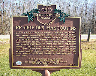
Historical Marker at Junction of
US Route 24 and State Route 109.
Photo Provided by Bob Morrison |
So it is not a surprise that French and Native American settlements occurred here along the Trade Route known as The Maumee River. One such settlement was named “Prairie Des Mascoutins”. As I read the text on the front of the historical marker, I am so amazed to contemplate the events of those days, and the fact that here I stand over 250 years later on the same piece of ground! The text on the rear of the marker tells a yet more recent history as much armed conflict and strife occurred here as European settlement of the Maumee Valley unfolded. It was not a peaceful process, as the Native Americans, The French, The British, the New American Continental forces engaged in many conflicts in both the French & Indian Wars, and finally the second war of independence- The War of 1812. Not until the conclusion of the War of 1812 did the North Coast of the United States, and our Northern border become established. The Historical Marker here at this site bears witness to much of what happened here! Click here to
Read the Text of the Markers.
Contained in The Henry County Historical Society's Oral History Collection, is a transcript told by Genevieve Eicher- a Wyandotte Indian Decendant- as to the location of this settlement. Click Here to Read the Transcript of the Oral History narrative.


